

American Thanksgiving today so happy turkey day to everyone. We arrived at the Valley of the Gods last evening and first impressions were once again AWESOME!! This valley is a mini version of Monument Valley. It is made up of tall red sandstone cliffs, mesas and pinnacles standing well above the relatively flat valley floor. There is 17 miles of dirt road that travel through the valley winding its way amongst the different redrock formations. On first site, the valley and the rock gives one a rather serene feeling although a bit eerie as well. You feel you are witnessing something special. This valley lies at the base of a 1200 foot bluff called Cedar Mesa (formed 250 million years ago) and is known to be rich in Anasazi ruins and rock art. John and I first learned of the Anasazi Indian Tribe back when we did a Jeep Jamboree years ago in the Arch Canyon here in Utah. The Anasazi Indians or "Ancient Ones" roamed this area between 200 and 1300AD. They are commonly believed to have simply "vanished" from this area leaving their homes and belongings for no reason. Some however, believe that they simply moved on eventually assimilating into other Pueblo Peoples.
Navajo legend describes many of the rock formations in the valley as ancient warriors frozen in time. It is believed to be a "place of power, where spirits reside".
We set off today down the Valley of the Gods road and saw many of the named monoliths that are along the road. The shapes and sizes alone are awesome. We eventually came to the Moki Dugway. This is often thought of as one of the most dangerous roads in the USA. It is 3 miles long and climbs 1200 feet to the top of Cedar Mesa. It is a shelf road with many switchbacks but believe me when I say it is NOTHING compared to the Shafer Switchbacks of the White Rim Trail near Moab.
A "dugway" is "a road or trail going through a high land from which is dug out to provide a path for transport allowing cattle and wagons to travel the hillside". This particular "path" was built in the 1950's by Texas Zinc Minerals to haul zinc/uranium ore from the Happy Jack mine to the mill in Mexican Hat.
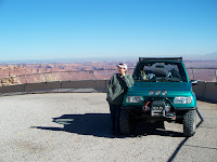
We found the trailhead to the Point Lookout Trail and headed on down. It was a wide sandy trail that initially took us through much taller pine trees than what we had seen near Moab and eventually became a Utah slickrock trail. We made it to the overlook and saw another trail far below. I of course did not go near the edge!! Call me Chicken!! This was a spur trail so backtracked and accessed Government Trail where we looked for Hat Rock. Nothing I saw resembled a hat but on the way back (as this was a spur trail as well) we found a cave dwelling. We took some pics and I hope you are able to see the chinking that was between the rocks. It was quite amazing. The cave was divided into little rooms. There is a picture with the truck in front of a sandstone dome and this is where the dwelling was. Whoever lived there was not tall as I could not stand up in the dwelling. It was interesting though and well worth the trip down this trail.
Time to start heading back so accessed Snow Flat Trail. This was by far the best trail of the day however it was getting dark and eventually we could not see much scenery. I'm hoping John will agree to do this trail again tomorrow. We got home in time to watch Survivor on TV and relax from another hard day on the trails!!
No comments:
Post a Comment