 |
| Headed out |
This morning we actually took the road out that we were supposed to take into this site but somehow we managed to take the "back way" in yesterday and that was less than optimum but we managed to find this sweet little spot despite our rather dubious entry!!
 |
| Utah 24 west |


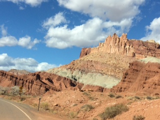
 We continued our journey today which took us through Capital Reef National Park. Thanks to Google.... I read that this National Park, situated in South Central Utah is about 60 miles long and averages about 6 miles wide and covers an area of 241,904 acres!! It was designated a National Monument in 1937 by Franklin D Roosevelt in order to protect the areas colorful canyons, ridges, buttes and monoliths but was actually not open to the public until 1950. Capital Reef National Park preserves the nearly 100 mile long "upthrust" formation called the Water pocket Fold - a rocky spine that goes from Thousand Lake Mountain to Lake Powell. The park itself was named for a line of cliffs of White Navajo Sandstone with dome formations - similar to the white domes often placed of Capital buildings. The word "reef" refers to any rocky barrier to land travel just as ocean reefs are barriers to sea travel.


 |
| Fall is still very much a part of this canyon with its incredible yellow colors clinging to the cottonwood trees. |

 |
| Once, a school house |
 |
| Capital Reef National Park Visitor Center |


 |
| Another sign and another turn.......more adventure awaits!! |
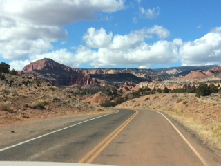
The travel through the forest offered several incredible vistas to view and there were many scenic turnouts. We did stop at one but unfortunately the camera on the phone just does not pick up the incredible awesomeness of the area.
There was a definite chill in the air but at these elevations, it is to be assumed "the norm"!! After all, it is November!!
 |


 |
| Awesome Views |


 |
| Finally.....I got the elusive road sign!! |
 |
| Summit 9600 feet |


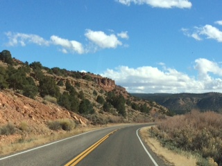
 As we travelled along Utah West 12, the scenery changed from mountain summits to farm land to uninhabitable ruggedness. The highway continued to carve its way through this country side avoiding the higher mountains while skirting their base. We did climb up in several areas and were met with more incredible scenery.


 |
| Sharp curves |
John of course was loving the drive and actually thought that this was one of the best roads we had ever been on!! Well.....I beg to differ!!
I do have to marvel at the engineering that went into the building of this highway and wondered about the poor buggers that had to pave it. Man, there was simply no room for mistakes when you were working a shelf trail like that.
It is a good thing we can now say that we have "been there, done that" because it is not a road that I want to take again anytime soon!!


The incredible beauty of Bryce National Park took up the end of our day. Although we didn't actually go directly into the park, the surrounding mountainous cliffs showed their splendor.
One has got to love Google as it abounds with information
Bryce National Park's (located in Southwestern Utah) major feature in Bryce Canyon which, is not really a canyon at all. It is a collection of great natural amphitheatres along the Eastern Ridge of Pausaugunt Plateau. The Park is distinctive because of its geological structures called "hoodoos" and their distinctive colors of red, orange and white provide incredible views.
It covers 35,835 acres and reaches elevations of 9000 feet. There are less visitors to this National Park than any other in Utah due to its rather remote location. That being said, one should not hesitate to make the trip to this unique area as it too holds so many incredible sites and is a recreation area for many different outdoor enthusiasts.


 Bryce Canyon City herald the entrance to the park. We entered the touristy town and quickly found the road we were looking for that would take us to a boon docking area for the night. John, once again, did his research for a free campsite and this one popped up.